Thursday, April 27, 2006

A fun retone

I was playing around with some storm photos today under the guise of "nothing is offlimits" -- i.e., toning for art, not for an attempt at being photojournalistic. I am continually amazed at the latitude afforded by RAW digital shots.


Original tone:


fairly easily becomes:


Ryan's Hood

Today's photo of the day is from Lanette. Lanette sent me a slew of cool photos about a week ago, and I've been a derelict and haven't even replied to her yet. Still, I thought I'd share the news that I now apparently have a hood! My hood is open to all of my friends, though I do ask that you extinguish any trashcan fires before you leave. Oh, and no knife-fights. This isn't that kind of hood.


Wednesday, April 26, 2006

Storm7 photo for sale

Man, I got a lotta inquiries on my April 23rd storm chase! I wasn't planning on selling anything when I posted this, but I've had a lot of people asking if they can buy prints. After a quick 8x10 quality control check (I had one printed at a local lab today to ensure that it was sharp and looked good as a print), I can sell the "storm7" photo (the vertical one with the lightning bolt that looks like this:


to anyone interested. The prices are as follows:


8x12 or 8x10 (your pick): $35

10x15 or 11x14 (your pick) : $50

16x24 or 16x20 (your pick): $100


The photos will be printed on metallic pearlecent paper, which, in past experience, has made colors look incredible. Note that 8x10, 11x14, and 16x20 will have borders on them (white lines on the left and right hand sides of the photo), whereas 8x12, 10x15, and 16x24 will not. However it's harder to find frames and mattes for 8x12, 10x15, and 16x24 prints. I can't gauruntee that the 16x24 prints will be super sharp -- the resolution gets down to around 160dpi at that size. However, what makes the photo cool is more the colors anyway, so it'll probably look really good even if it's a bit soft.


Hit me with an email at digicana at gmail dot com if you're interested; I'll be going through Paypal for this.

Tuesday, April 25, 2006

A few more HDR experiments

Earlier last week I mentioned a new photographic process known as HDR (High Dynamic Range) photography. Essentially, it involves taking multiple exposures of a scene spanning the entire dynamic range and then using a program to smash them all together. Here are a few more HDR experiments. As you can see, the effect is striking, though more than a touch unrealistic. I'm still trying to find the magic way to make this look "real". It does seem to have a lot of potential, though.


Click to enlarge in a new window.


Nebraska state Capitol


Another capitol shot.


Nebraska state governor's mansion.


Here's my experiment with using HDR for weather photos. If you can get the sky to sit still, it can do some very interesting things. HDR photos kinda seem like impossibly exposed Velvia photos on crack, which can be good or bad, depending on if having your photos as saturated as a Disney cartoon is to your liking or not.


Lastly, here's a comparison of a "normal" photo I took while attempting to expose for the sky and the brightly reflective car versus the same shot using the HDR process:


Monday, April 24, 2006

April 23rd chase

Note: All photos get SUPER HUGE (850px wide) in a new window when you click 'em.


Yesterday's chase was what I'd call "sweet-ass-mamba-jamba". It was totally a long shot, and I ended up catching a really, really beautiful storm. My friend Darren Addy and I left out of Kearney at around 18Z and dropped south via Holdrege to Hays, Kansas. There we got gas and leeched wifi off of Days Inn. (BTW, if you're looking for a data stop, Hays has a ton of open wifi. I mean, seriously, you could probably hold a LAN party in the parking lot of Days Inn.) Anyway, I was feeling a little better about the day as I saw on the surface obs that Tds of 60 were starting to pump their way up into eastern KS. The SW flow wasn't helping things much were we where, though, and the Tds hovered in the mid 50's. Upper level winds were still mediocre at best accordin to the profilers, but, hey, it was almost May... I had hope. :) Eventually the dryline initiated to our south down by KDDC. The storms looked pretty boring on radar, though I now realize that that was an illusion due to the very high bases of the storms and that we were only using tilt 1 to view returns. (Why that didn't occur to me until later, I dunno!) The Tds down there weren't too impressive, either, not that they were much better up where we were. I stayed north, as there was no way to get that far south quickly and because I still had my fingers crossed that something would initialize near the now warm front. It was tough not to go rabbiting south, because I've been burned more than a few times by waiting too long to get a move on.


It got to around 22:30Z or so and I noticed that the Tds in Hays were actually dropping -- they were now in the mid 40s. Not a good sign for where we were; I guess the dry air was mixing in. But on the sat shot, it appeared that a field of cu were starting to form about 40 miles to our east, so we hit the great east-west interstate that is I-70 and drove east. We came upon the cu field about 30 minutes later. A small area had become congested, and it literally began initiating as we drove under it. I pulled over at a reststop north of Ellsworth and had a ham sandwhich with Darren while we watched it go nuclear just to our west-northwest.


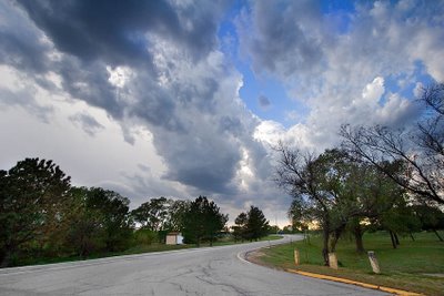
(not nuclear yet, but you can see the tower peeking out beneath the crud below)


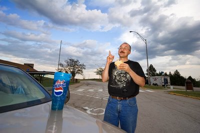
Darren demonstrates the Socratic Method of eating a ham sandwich.


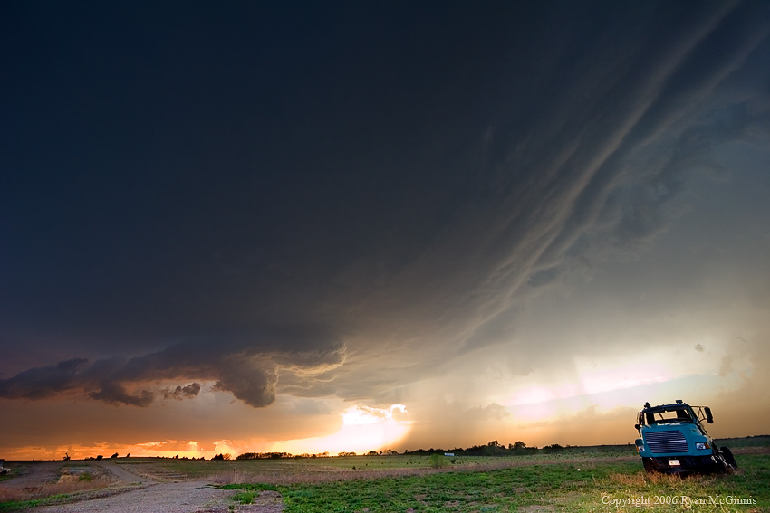
There is nothing cooler than watching a vault form overhead and hearing a storm's first rumble of lightning! Eventually we decided to go east, as the storm was starting to slide just to our north. So we west east on I-70. Along the way, we passed Amos & crew. There was a black 'stang in my rearview, too, so I'm wondering if Mike wasn't in the hunt. Amos got off on the same exit we did. Turns out that was probably one of the best places to witness storm development in central Kansas -- right off the exit was a flat field about 3 miles long with an easy place to pull off and park. Park we did, and wow, did the cell put on a show. Oddly, the storm did not produce much of a radar signature for a very long time -- it was almost invisible to radar. At least on tilt one. ;) Later I realized why I wasn't getting radar returns -- the base of the storm was above the tilt-1 beam. Doh. After a bit, the storm dumped it's core and split. This was interesting to watch, as I didn't understand what was happening at the time. I've seen right splits on radar and know what they mean, but I've never actually been able to watch one with my own eyes as it happened. Amos filled me in. Anyway, the right-mover started moving back to the southeast, which put us in pretty much the best position possible to watch it. The inflow was a good 25 or 30mph. Eventually, to the surprise of pretty much everyone, the darn thing formed an RFD and demonstrated a very obvious meso and wicked-looking wall cloud.


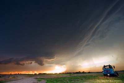
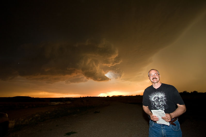
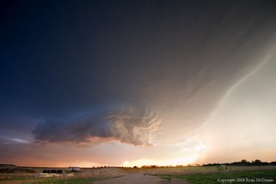
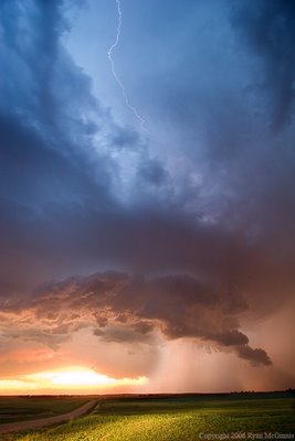
It really turned into a mothership of a storm -- check out the striations at right! I have a new respect for really high-based storms. Around sunset, this storm was one of the most beautiful things I've ever seen. I mean, I put it up there with the Grand Canyon and redheads. The color and depth on this storm was amazing.


From the Amos crew (if you don't want your picture posted, just lemme know! :))


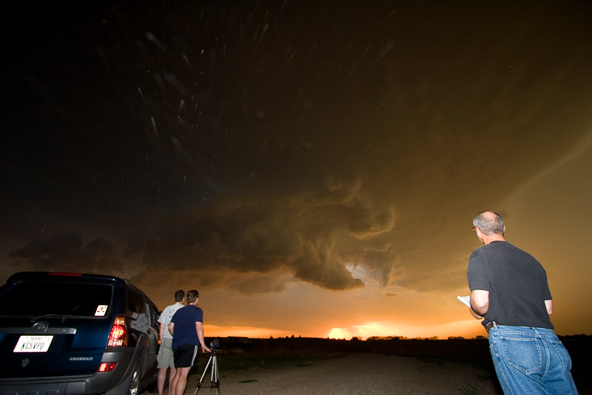
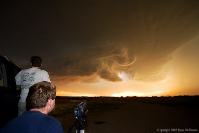
The streaks are actually raindrops that the flash illuminated. I think. If you look close, you can see a small funnel waaaay up in the meso.


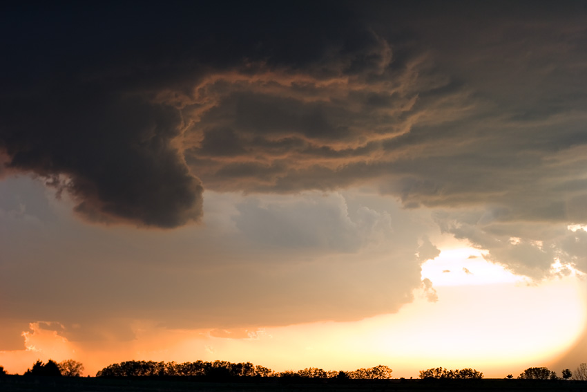
Eventually, we repositioned one exit east on the interstate. What a beautiful, beautiful storm.


Props to Amos for his headlights, which makes this photo better IMO. I was a bit frightened when I took this, as I was on top of a freakin' hill with a metal tripod while zeus zots were falling all over the place.


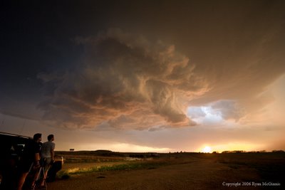
Darren actually has some hilarious and cool video of us coming up to the top of a hill behind Amos, ominous as all heck, when suddenly a parade of tumbleweeds blows by. Lol. The storm never put down a tube, but who cares?! This was the best storm I've seen in a while -- truely spectacular in it's beauty.


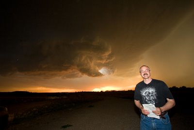
Darren and Ryan give this supercell two thumbs up!


Anyway, great chase. Hope I didn't bug Amos too much, as we followed them around a bit without asking after we converged the first time. Thought I'd give my navigator a break and let him shoot some video instead. ;)


Wow, is it only April?!


*edit*


Man, I got a lotta inquiries on this one! I wasn't planning on selling anything when I posted this. :) I'll try to contact those interested by email, but after a quick 8x10 quality control check (I had one printed at a local lab today to ensure that it was sharp and looked good as a print), I can sell the "storm7" photo (the vertical one with the lightning bolt) to anyone interested. The prices are as follows:


8x12 or 8x10 (your pick): $35

10x15 or 11x14 (your pick) : $50

16x24 or 16x20 (your pick): $100


I print photos of this type on metallic pearlecent paper, which, in past experiences, has made colors look incredible. Note that 8x10, 11x14, and 16x20 will have borders on them (white lines on the left and right hand sides of the photo or the top and the bottom of the photo, depending of if it's a vertical or a horizontal photograph), whereas 8x12, 10x15, and 16x24 will not. However it's harder to find frames and mattes for 8x12, 10x15, and 16x24 prints. I can't gauruntee that the 16x24 prints will be super sharp -- the resolution gets down to around 160dpi at that size. However, what makes the photos cool are more the colors and tones anyway, so it'll probably look really good even if it's a bit soft.


Hit me with an email at digicana at gmail dot com if you're interested; I'll be going through Paypal for this.

Friday, April 21, 2006

Carhenge


Today's photo of the day is from Carhenge around four years ago. Shot on Fuji Velvia with a Canon EOS-3. That was one heck of a fun trip! An 850 pixel version pops up if you click the photo.


There is a smiley face hidden in this photo. No, I didn't put it there. :)

Thursday, April 20, 2006

HDR photo experiments

Note: most photos below get larger when you click them

HDR -- High Dynamic Range -- photos are something entirely new to me. Apparently Photoshop CS2 supports HDR images natively. In this instance, I created HDR iamges by tripoding my camera, taking a number of photos bracketed at 1 or 2 stops per step, then importing the photos into Photoshop, which created the 32 bit file. From there, I downsampled to 16 bit, telling Photoshop to try to preserve detail in both shadows and highlights. A little tweaking in 16 bit, then downsample to 8 bit, then save -- viola!


Here's an example. These photos and a few others not pictured(presented here as a collage):


were merged into a 32bit file, then sampled down as described above. Final result was this:


As you can see, detail is preserved everywhere -- the sun is not blown out, the sky is blue, and the capitol is not a giant shadow (which it would normally be).


I found that it also works handheld with my wideangle lens. These three photos shot handheld-bracketed:


were used to create this:


One thing to note is that there is a sort of "unnatural" feeling to HDR produced images. At least, there is to me -- the reason being that the files are actually containing more exposure information than the human eye can resolve. That is, our brains can't process this exposure latitude when looking at this scene, so it seems strange to see this much latitude on the screen. That, and the brain processes exposure much differently (and much better) than Photoshop does! However, with a little post-processing, it will look normal again. Here's the photo above after a little tweaking:


Here's one last shot. The interior, as you can see, is entirely in shadow when the exterior is properly exposed:


And when the HDR processing is done:


And after the tweaking to make it look a bit more like reality:


Quite cool, though I get the feeling I'm going to need to do a lot more learning with this. Likely all HDR images will require a significant amount of hand-toning to get contrast back in places where it is needed -- much of the contrast is lost when Photoshop is finished processing in HDR. Still, this is an incredible way to capture an enormous latitude of exposure information in one file, and offers a ridiculous amount of toning opportunities. Can't wait to play with it more! :) I'll leave you with two photos, one a straight-from-the-camera exposure exposed for the outdoors, and one that has been processed from around 10 shots that spanned the dynamic range. Pretty cool:


Thursday, April 13, 2006

Cityscape


Today's photo is another from San Francisco (click to enlarge). It's shot from atop a tall hill; the buildings look this way because of the incredibly steep hills that make up 'Cisco. Whenever I read articles about the hills "liquifying" during an earthquake, and what that would mean, this image comes to mind. I may try printing this big some time -- it would make an interesting abstract.

Saturday, April 08, 2006

After the storm

Today's photo of the day is from Thursday. This is after the storm, more or less. Sitting north of Beatrice, just enjoying the sunset. Looking north.


Friday, April 07, 2006

Yesterday's chase

I'll cut & paste what I posted to Stormtrack:


Had a really fun chase today. Started out in KBIE, then scooted east to Hebron. Eventually figured the high LCLs and dry air up in Nebraska (60 Tds my foot!) weren't going to do me any good, so I dropped down into Kansas on 81. Caught the cell of the day, but got behind instead of in front of it. At one point I had to choose whether to punch it and try to beat it to Clay Center on 24 or to wait it out just west of Idana. Chose to wait it out -- talked a couple of truckers into waiting, too. Once the circulation had passed over 24, I jetted to Clay Center. Debris everywhere out by the airport. Saw at least one home pretty totalled, and metal sheeting from a disintegrated barn or shed spread out over a good half mile. Trees uprooted as well. Bopped north on 15 from Clay Center, then stairstepped NE on the county roads. Finally saw the tornado in a low contrast type deal about 5 miles away when I got near 36. From funnel to touchdown in about a minute, then from thin funnel to a stovepipe for a couple more. After that it either got wrapped in rain (remember, we're looking from the south) or lifted. Saw some more damage when we rejoined the highway east of Washington. Followed it north a bit more on 77, but there wasn't much to see from there.


Wish I could've got photos of the tube, but I needed a telephoto to do that, and didn't have one. My friend did, but he had to shoot while we were moving because there was traffic behind me and nowhere to pull off on the old county road we were on, so they came out blurry. We did have a ton of fun, though!


(click to make really, really big)


Shot looking north-northeast from just north of Clay Center. I wasn't going to drive much into this until I watched it a bit, as our radar wasn't updating (no good cell coverage), and I could look straight up and see the whole vault of convection rotating right above me. Man, that's quite a sight, looking straight up 40,000 feet, and seeing the base right above and the knuckles peeking out in the stratosphere and everything moving in different directions. Hope everyone in Clay Center came out of this one okay.

Wednesday, April 05, 2006

Lol


Josh just forwarded this funny picture of me. He must be going through and filing his archives. :)


The joke was that the well was filled in and only about two feet deep.

Tomorrow

Right now I'm eyeballing NE Nebraska and NW Iowa. Both the 250mb and 500mb jets exit here, with a ton of diffluence. Tds in the 60s all the way up to Sioux City, if the 0Z NAM is to believed. However, the dryline doesn't look too shabby further south -- I need to see the Tds tomorrow and how far north they made it before I know where I'll go. I'm going to be irked if I drive all the way up to Sioux City and watch a tornado roll by Lincoln! :)


Here's hoping that nobody gets hurt or killed tomorrow, be it chaser or resident of the plains. It's going to be a whopper of a day, I think, in Nebraska, Iowa, Missouri, and maybe Kansas.


*edit* I may be misreading the 0Z charts -- it seems that everyone on Stormtrack disagrees with what I'm seeing. Off to study it more.


*edit again* Okay, I'm going to stop using Earl Barker's maps to try to find fronts. Too cluttered. COD's maps show the warm front & triple point settled around SE NE at 12Z, then lifting northeast a bit by 18Z. If that turns out to be the case then, um, I'm probably not going to have to go far tomorrow -- maybe just get out of the city so I don't get caught in traffic when the show starts. I like the wf way more than the dryline now.


I am going to pull my HAIR out if I end up in NW Missouri tomorrow. :)

Tuesday, April 04, 2006

Thursday (again!)


It looks like Thursday is shaping up to another chaseable day. NAM progs a 885mb low smack dab over northcentral Nebraska at 18Z this Thursday, with most of eastern Nerbaska in the warm sector with a dryline punching through by 0Z. Tds near 60, though it seems a more than little shallow according to the latest NAM.


Check out the 500mb winds -- 60kts! Greeeat. (But at least this time we have some good directional shear. If the models pan out, of course.) As someone on Storm Track put it, "chasers will need to attach their chasemobile rocket boosters that were used in previous chases this year". Bunkers is showing a good 40+ knots storm motion. I'd complain but it's only April, and by most rights I shouldn't be seeing these kinds of storms up here yet. So you take what you can get.

Abstract

Today's pic of the day is an abstract of a pier in San Francisco. I took this while waiting for a ferry.


Monday, April 03, 2006

Pic of the day


Another shot of the San Francisco skyline. Amazing how condensed that place is!

Sunday, April 02, 2006

Musee D'Orsay


Today's photo is from the archives. I've been having fun with the slide scanner I got from Josh. This was shot in the interior of the Musee D'Orsay in Paris; I have a feeling the architect had something like this in mind when he installed the giant transparent clock. Shot on Kodachrome 50 I think. As always, clickin' it makes it way bigger.

Saturday, April 01, 2006

CPSWS 2006

Just got back from the Central Plains Severe Weather Symposium. Met up with Darren Addy & Mike Peregrine; Mike, who's a very experienced chaser, was giving a talk on recent chases (including one in western MO that nearly did him in two days ago). Got to see the radiosonde launch (see pics, which get bigger when you click them) and shoot the breeze over lunch. Mike was having some good success with his photos -- I think that if I can build a big enough library of photos, I might buy a table next year. Good times!


Getting the weather balloon ready to go.


5...4...3...2...1...


Up, up, and away! (The radio at the bottom of the balloon almost hit a kid in the head as this thing went skyward! :))


Mike giving the talk on chasing. At one point, Mike had a bit of technical difficulty (something that seems fairly common with the setup that's used at this event each year), and Darren started shouting Macintosh troublueshooting tips from the back. Keep in mind there were probably 200 people in the audience!


Mike at left, Darren at center, all the good photos in the middle. Keep in mind that this lens stretches and distorts the heck out of everything at the frame's edge. Lots of other chaser were MIA -- Tim Vasquez, Nick Grillo, Darin Brunin, etc. Tables rented but nowhere to be found -- they probably skipped school for a daytrip down to Kansas. ;)


A kid checks out the "tornado machine". If only it were that easy, kid!


Fun times!

Chase report 3/30/06

Chase report from Thursday (crossposted from Storm Track":


No tornadoes today for me -- and not much of photogenic anything due to the persistant cloudcover. But a really fun chase, nonetheless, especially considering it was in my back yard. I started out by driving west a bit on I-80 and waiting at a rest stop just east of Goehner, between Lincoln and York. I got the impression that the dryline storms out west were going to be completely linear, and I noticed that convection was trying to pop from an area basically overhead to points south into Kansas. So I dropped south. Eventually, a supercell formed south of Beatrice, so I headed back east to HWY 103, then dropped south to Crete. As I was doing this, the Beatrice cell was really getting wound up, and given the fact that everything was tearing along at 50+mph, I only just barely got NE of the cell on HWY 33 before the core could catch me. This was actually pretty cool, as CGs were dropping left and right around me about once every 2 or 3 seconds -- and they were really, really close, close enough to get the 'radio hum' before the strike. I stopped about 2 east of Roca to watch the 'meso' (not too impressive looking) roll by and to get in position to try to close in on it (briefly) once I had a clear shot at the inflow area. Unfortunately, the storm started falling apart at around this point. Still, it was the only game in town at the time, so I tailed it by taking the grid roads to the north. While I was doing this, I noticed another cell forming to the south. To be honest, I didn't have a lot of hope for it, as it had plenty of crap convection surrounding it, but the original cell I was on was limping into Lincoln like a wounded deer, so I decided to "try" to get east before the core of the new storm overtook me. Drove east on Hwy 2. No luck, but at least I only caught the blinding rain and wind part of the core, not the hail part. It seemed pretty clear, though, once I got to Syracuse, that the storm I was positioning for wasn't going to make the cut. I munched out on Slim Jim's & Strawberry milk as disorganized storms marched overhead. Once it was clear the the squall was going to march in and finish the day, I decided to go and try to meet it somewhere picturesque, so I took HWY 2 back to Lincoln. Got to the outskirts of Lincoln just before the squall did, and let me tell ya -- it was one of the more visually frightening things I've ever seen. I knew I wasn't in danger, but it looked like something out of one of those Apocylpse movies. I sat in my car with my jaw dropped as I watched a massive, impenetreble fist-like curtain of rain sweeping across the horizion towards me. I mean you could really see it coming. I parked next to HWY 2, and boy was it was making the traffic on HWY 2 freak out! Once it got right on top of me, I could literally see the power of the downdraft -- the rain flying horizionally several thousand feet overhead, and then whoosh! The car rocks as the gust front hits and the visibility goes from 5 miles to 5 feet in just a couple seconds. It was all over in five minutes, but wow! I'll never get the image of that squall coming in out of my head. It's one of those things that's so surreal that you wonder if you're dreaming.


Now, I saw no tornadoes today, but I still had an awesome time. Between the wondergul squall and the challenge of getting in position (even though the storms died), I had a good chance to shake down my equipment setup and have fun doing it. Plus, the usual chase magic was following me around. For example, at the gas stop in Syracuse, the clerk who was ringing up my Slim Jims seemed really distracted... and then she suddenly got this huge smile and blurted out to me that her sister, who has had cancer for the last 3 years, just called her and told her that her cancer was in remission. Outside, the last storm had just rolled through and the sun was poking through the clouds for the first time of the day. Yeah, it was a pretty cool chase.